- Simulate a telemetry file (or get real telemetry file)
- event_obj = Obj_New( 'hsi_eventlist' )
- event_obj-->Simulate (input your preferred model
 )
)
- event_obj-->WriteTelemetry
- event_obj-->WriteFITS
- Create Calibrated Event List
- ceo = Obj_New( 'hsi_calib_eventlist' )
- det_index=4 ; or any other number from 0 to 8
- coll =ceo-->getcalibeventlist(det_index,filename='telemetry.fits')
- calib_event.roll_angle
- calib_event.phase_map_ctr
- calib_event.gridtran
- calib_event.livetime
- calib_event.count
- calib_event.modamp
- calib_event.background
- Select 180o subset of roll angles (average only after step 7.)
- Find approximate flare location
- External information (H
 , SXT, OVRO, SERBL?)
- Internal information (modulation rate or bproj map)
- Trial and error
- Select map center (The closer to flare, the better the vis)
- Generate modulation profile (rebin appropriately)
- Generate visibilities (modprofile_to_vis.pro)---average mod 180
- spin-based (Triassic version)
- phase-based, non object-oriented (Jurassic version)
- phase-based, object-oriented (Paleolithic version)
- Note in progress: puzzling sign of imaginary part
- Uncertain effect of least-square fit on statistics.
- Pleistocene version--Real Soon Now
- Select polar center (x_pol_ctr,y_pol_ctr) -- near spin axis or Sun center
- q = (U,V), depends on det_index, grid_angle, roll_angle

- R =

- Shift phases to polar center:
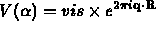
- Apply polar recipe:
- Read the visibility amplitude and phase vectors
 .
.
- Compute the FFT in
 space for each complex vector V,
obtaining the complex coefficients
space for each complex vector V,
obtaining the complex coefficients  .
.
- Using downward recurrence relations, compute the matrix

- For each radius (R) in the map and each collimator (j), compute the
vector
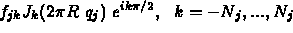
- Obtain the one-dimensional FFT, giving the
 dependence at
that radius (one column of a single-subcollimator map).
dependence at
that radius (one column of a single-subcollimator map).
- Add the one-collimator maps together, weighting by the UV
radius
 .
.
Next: HESSI Imaging Programs
Up: STEPS TO POLAR MAPPING
Previous: HESSI Imaging Programs
Solar Studies
Mon Jul 26 16:41:11 PDT 1999